Friday, 31 December 2010

Yateley Heath and Hawley Common

Yateley

1973
1:20,000
25'
Black, Blue, Yellow and Brown
SU8358 - Hampshire SCOA, England
Survey by Reading OC
Drawn John Shelton
Modern maps: Hawley  Yateley Heath


Yateley Heath and Hawley Common are regulars on the fixture list and have hosted major events up to JK level. This is an early edition and no doubt there were a few maps before this one.  A full five colour job at the then common scale of 1:20,000, it covers a vast area of heathland and forest. For some reason the mapper went for a portrait format, as a result the magnetic north lines are horizontal. Despite the strange orientation, and the symbols being inconsistently oriented, this is a very fine piece of pen and ink work.


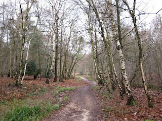
Public Footpath near Hawley Hill


Yateley Heath Wood

Monday, 29 November 2010

Great Breach Wood

Great Breach Wood
Jan 1974
1:10,000
25'
Black, Blue, Yellow and Brown
ST5031 - Somerset SWOA, England
Survey by David Roach
Drawn David Roach


 A study in accurate use of Letratone. This is a remarkable effort for its time and quite striking in that an area of over 90% fight did not use green.  The problem was 2m high brambles.
The map was made in nearby Millfield School, who operated a fully fledged club running events up to what used to be called badge events and also put in a bid for the 1980 Southern Championships.  This forest was on their doorstep, but fortunately efforts were later directed to the Quantock Hills and this bramble infested hell hole was allowed to lapse.  I believe that Millfield now own part of the forest. 

© Copyright Neville Goodman and licensed for reuse under this Creative Commons Licence.
 

Tuesday, 23 November 2010

Kershope Forest
Jun1973
1:20,000
25'
Five colour
NY5283 - Cumberland NWOA, England
Survey by Border Liners OC
Drawn R Whitworth


Another from the 1:20,000 era. This one must have been something special - a full five colour job in 1973. It was used for the Mammoth, the forerunner to today's Lakes 5-days.   Kershope is not really an orienteering forest, it is mainly Sitka spruce and part of the huge area of artificial woodland which straddles the England - Scotland border.  It does not seem to have been used for many years and much of it has been felled and replanted. One for the Mountain bikes?

Kershope today

Clear Fell area in Kershope Forest
  © Copyright Walter Baxter and licensed for reuse under this Creative Commons Licence.

Monday, 22 November 2010

Puddletown Forest

Puddletown Forest
Jan 1972
1:15,000
25'
Black brown and blue
SY7392 - Dorset, SWOA, England
Survey by Ian Keith, Ron Wilton
Drawn Gary Court


Puddletown was a favourite in the 1970s and hosted the 1974 British Relay Championships.  The chainsaw has taken its toll and much of it was felled either side of 1980, although modern photographs suggest that it still has a lot of forest left.
Puddletown's main feature was the huge depressions, caused I think, by dissolving chalk under the pebbly surface rock. These of course were often used as control sites.
This map is from the first days of tweaking OS maps and is in the now rare scale of 1:20,000. The next edition in 1974 was 1:10,000 and something of a masterpiece.  
I have not heard of Puddletown being used for orienteering in recent years. 

Sunday, 21 November 2010

Five colour maps

The name harks back to those wonderful words in event flyers - when getting a full roster of colours on an orienteering map meant something special.   Long before laser printers and OCAD, when map production was in the hands of a small minority who had mastered the black arts of Letraset, scribing and aligning all the colour plates.

This blog is the product of a realisation that our mapping heritage may be lost, so time to dig out my 36 year old map collection and find a few gems.

----

Castle Neroche and Staple Common
Feb 1973
1:15,000
25'
ST2715 - Somerset, SWOA, England
Survey by SWOA members
Drawn DJ Parkin
Modern maps: Staple Hill  


A notorious map from the latter days of the transition to specialist mapping.  It was used for the 1973 South West Championships, I missed running on it by a couple of months.
Very much an OS conversion job, notice the lack of magnetic north lines, they were added as map corrections. There were a lot of map corrections.
Also famed for its blot.


Neroche went on to hold many prestigious events in later years including a national in 2002. A lot of the solid yellow on the west side of the map is now forested.

Castle Neroche is a beautiful place and well worth a visit. I have run there twice, once during a contour only exercise while at school and in the 2002 National Event.